


Alpine: 28 miles S of Springerville; 75 miles E of Pinetop-Lakeside; 95 miles N of Clifton
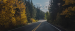
Winding southward from the Springerville-Eagar area to Clifton and Morenci for 100 miles, the Coronado Trail (U.S. 191) is one of the most remote, little-traveled—and, truth be told, dangerous—paved roads in the state. Because this road is so narrow and winding, with dozens of 15 mph curves, it’s slow going—meant for people who aren’t in a hurry to get anywhere anytime soon, and who don’t mind sharing a clifftop highway with one logging truck after another.
The Coronado Trail is named for the Spanish explorer Francisco Vásquez de Coronado, who came to Arizona in search of gold in the early 1540s. Although he never found it, his party did make it as far north as the Hopi pueblos and would have traveled through this region on their march northward from Mexico. Centuries later, the discovery of huge copper reserves would make the fortunes of the towns of Clifton and Morenci, at the southern end of the Coronado Trail.
The road runs through a beautiful area, however, often called the Alps of Arizona. Even if you don’t drive the length of the route, it’s worth exploring some of its outdoor pleasures.